I noticed a while ago a road/path that used to exist but seemingly no longer does. It was this road/path between Cadger's Brae and the Polmont Burn.
So me & my trusty Dawes took a trip out to that space between Westquarter and Polmont to see if anything of it remained.
It did.
Above and beyond the most obvious of obvious [the desire line] was the brickwork strewn about that was not relevant to the Estate Walls. Down the Rabbit hole.
Before long, as I had expected, evidence of previous occupation [or is it evidence of poor demolition] began to make itself known.

There are clear walls with subdividing returns, and other brick and stonework which fit with the map.


Nothing spectacular, just interesting [what was fantastic was that a fox ran past me at about six feet to my right at about this point]. I continued to the end of the path, where the 1890 OS map said a pump stood.
However, for the little I know, all I found was this line of bricks, which definitely seem much later than 1890.

After this, I crossed the burn [oof, wet feet] to the right of way and cycled home. Still do not regret it.

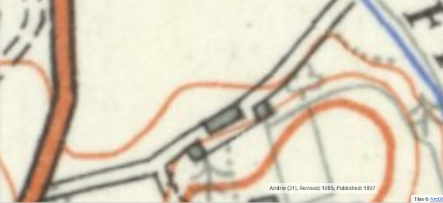
Taken/Borrowed/Stolen from the most fantastical NLS Maps.
So me & my trusty Dawes took a trip out to that space between Westquarter and Polmont to see if anything of it remained.
It did.
Above and beyond the most obvious of obvious [the desire line] was the brickwork strewn about that was not relevant to the Estate Walls. Down the Rabbit hole.
Before long, as I had expected, evidence of previous occupation [or is it evidence of poor demolition] began to make itself known.

There are clear walls with subdividing returns, and other brick and stonework which fit with the map.


Nothing spectacular, just interesting [what was fantastic was that a fox ran past me at about six feet to my right at about this point]. I continued to the end of the path, where the 1890 OS map said a pump stood.
However, for the little I know, all I found was this line of bricks, which definitely seem much later than 1890.

After this, I crossed the burn [oof, wet feet] to the right of way and cycled home. Still do not regret it.
Comments
Post a Comment